Jarles himself survived with his son since they were on land headed to the south pole-- 1500 miles south.
From "Yachting World" magazine, I found this....
quote
www.yachtingworld.com/.../antarctic-deaths-enormous-ramifications-6330
Mar 11, 2011 ... There is likely be a clamp-down on yachts sailing to Antarctica ... their last reported position around ten hours after the distress signal, but found .
unquote
Note this again...
There is likely be a clamp-down on yachts sailing to Antarctica
Apparently, Jarles was exploring the area of the Ross Sea. Here's a map of the ISLAND (associated with global earth) and a map of the PERIMETER (associated with flat earth).

Notice that the Ross Sea... under the Ross Ice Shelf presumably-- is NOT in the sector that is devoid of stations-- which is where the article says Jorge Andhoy went. I'm still confused on this point. Andhoy's yacht was 17 miles from Scott... right in there with LOTS of stations within a close range. Contradictions in the story and my understanding still have to be resolved-- suffice it to say that his mission led to calls for better control over private yacht explorers... that's a key point. Note as well that there is a Byrd (US) station south of Russkaya on the coast between .... Scott/McMurder and Rothera/FossilBluffs further north and east.
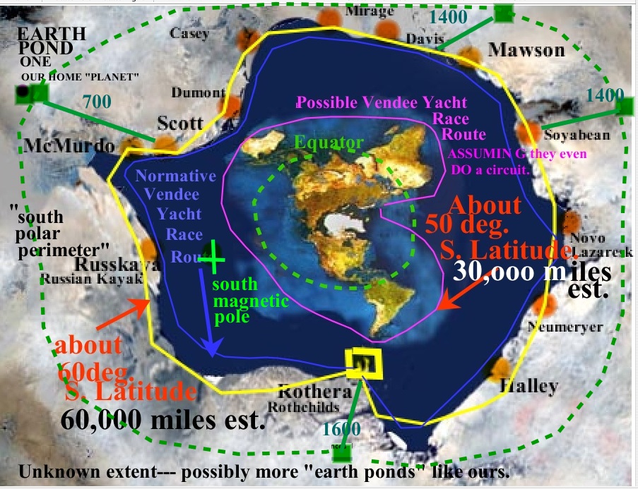
Note in the above map that Jorge Andhoy was actually very near Scott-- after all-- when he started to the "south pole". I've seen articles where it is said that McMurdo/Scott are the gateways to the south pole-- and that ALL missions to the south pole originate there. That would make sense on a flat earth perimeter antarctica as above. Starting from Halley in the lower right doesn't makes sense although I've seens maps of missions to south pole from there as well... beyond resolution of this issue right now. Note as well my approximate lines for the idiotic fake Vendee Yacht Race... in my opinion. How can yachts "race" around the approximate 50 degree latitude and still have food and supplies? It doesn't seem possible... .and a race makes no sense out on the dangerous high seas.... at least to me.
Rick says-- I've noted before that the area of the Ross Sea is devoid of airports, on this blog. I recently looked more carefully at the only station between Rothera and big installation at McMurdo (which DeNugent's readers are calling a military base)... the Russian Station-- Russkoya. I can't find a landing spot there yet. This stretch of territory might be much longer than the "island map" conveys to make up the extra [60,000-8,000 mile = 50,000 mile] coastline of the Perimeter-version of Antarctica.
That article from Yachting World above reads as follows...
quote
The Ross Sea, where Andhøy and his companion were dropped off, is a part of the continent that hardly any sailors visit. This vast region is usually iced in until late February and refreezes in March.
unquote
Rick says-- Now why should that be? I mean-- why should it be any different THERE as opposed to the "other side" of the "island"? Shouldn't freezes and thaws occur fairly regularly and evenly around the entire island, from winter through summer? Logically, you would think so. But apparently, this is not so. Furthermore, on either side of Ross Sea are Rothera, and around the the west, there's McMurdo-- both EASILY accessible.
The Yachting World article continues and confirms my previous view...
quote
Unlike the Antarctic Peninsula, which sees between 30 and 40 visiting yachts each season, the Ross Sea offers very little shelter or protection and few places to get securely tied in.
unquote
Rick says... Well apparently the Russians don't neccessarily agree. They have a station Russkoya that I've been looking at. I'll post it to the alpha index below shortly-- and you can see it for yourself. You would think Jarles Andhoy would have made that station a definite stop on his tour. I certainly would. As well, Jarles Andhoy and crew apparently DID find a place to go ashore and got their vehicle land-bound too.
quote
Andhøy had not obtained the necessary permit to visit Antarctica and so did not comply with the due diligence and search and rescue plan entailed. He is reported to have loaded his yacht which, according to his website, displaces 25 tonnes with 5 tonnes of extra gear, including all terrain vehicles lashed on deck.
unquote
Source
Read more at http://www.yachtingworld.com/blogs/elaine-bunting/antarctic-deaths-enormous-ramifications-6330#aFVvcjJfxpoEpqEs.99
more quotes
“You have to apply to one of the Antarctic Treaty countries for a permit and you have to meet stringent environmental concerns, a search and rescue plan and you have to have insurance with a very high level of liability. If you don’t you can be prosecuted.”
Read more at http://www.yachtingworld.com/blogs/elaine-bunting/antarctic-deaths-enormous-ramifications-6330#aFVvcjJfxpoEpqEs.99
unquote
quote
He warns: “Yachts are seen by the Antarctic Treaty as loose cannons. They lurk around and go everywhere in self-mode. Cruise ships especially are looking out for yachts making mistakes,” Novak says.
Antarctic Treaty countries, which issue permits to their national vessels, are determined to crack down hard on yachts that flout regulations. The Norwegian Polar Institute, from which Andhøy should have obtained a permit, is prosecuting him and he is currently awaiting trial.
unquote
Rick points out-- Jarles and son got on land with their vehicle but left the others on the yacht who "were on their way back"... back where? To "Scott" which is next to McMurdo. This is a contradiction. Either they were on the coast at Ross Sea OR they were going out and BACK to Scott. Which was it?
quote
Three yacht crew were lost in February when an expedition led by Norwegian sailor Jarle Andhøy, 34, went wrong.
The former naval diver and instructor for the Norwegian Rescue Company and a self-styled ‘wild Viking’ adventurer had led a crew of four from Christchurch, New Zealand to the Ross Sea in Antarctica on his 47ft steel yacht Berserk.
Here he and 18-year-old Samuel Massie disembarked with all terrain vehicles for a journey of almost 1,500 miles to the South Pole.
Those left on the yacht, Norwegians Robert Skaane, 34 and Tom Gisle Bellika, 36, and South African Leonard Banks, 32, were on their way back and only 17 miles north of the Scott Base when they met a storm and set off their EPIRB on 22 February.
unquote
Rick says-- Here's a 1 hour documentary of perhaps THIS VERY JOURNEY... or another similar one led by Jarles Andhoy. I'm unable to tell. I haven't watched the entirety of it yet but will post it now for my increasing numbers of readers to enjoy. My primary method for travelling around the perimeter of either the island or the plain-- is via air-- however lately, I've been reconsidering ocean travel and now I'm considering private yacht. Keep in mind the yacht race still exists and is conducted every 4 years from France-- which I currently believe is a hoax. Nonetheless, this yacht adventure is interesting. I'll also research EPIRB which I guess is an emergency channel of some sort.
Could be a psy-op in order to dissuade people from travelling in that area....or an Amundsen centenary media story...
ReplyDeletehttp://www.tv2.no/a/3428561
The expedition is being criticized by the Norwegian Polar Institute, which must approve all Norwegian activities in the Antarctic. Andhøy believes Prime Minister Stoltenberg has given him the green light.
- We do not need permission to walk down here. Jens Stoltenberg told me that I could travel to Antarctica and I took as a clear invitation and then I figured it was okay, says Andhøy to TV2.
Jarle Andhøy must now be prepared for damages, according to Jan-Gunnar Winther, director of the Norwegian Polar Institute.
- It is used heavily in search and rescue efforts. It can therefore subsequently be brought claims against the expedition, and it can be very expensive. We speak enough about millions, says Winther. [google translate]
The "angry" family members...
http://www.vg.no/nyheter/innenriks/moedre-setter-foten-ned-for-berserk-serie/a/10098654/
They didn't want a documentary made...***
but the ?psy-op? continues
http://www.nrk.no/troms/ny-antarktis-anmeldelse-mot-jarle-andhoy-1.12374101
Good gracious, he's done it again, allegedly this last Antarctic summer...
This time for a sailing trip with celebrities Anne Kat. Hærland *on board.
*a satrical comedian. Also on board was Petter Baarli a guitarist.
http://www.vg.no/rampelys/anne-kat-haerland-med-paa-ny-berserk-ekspedisjon/a/23404151/
Because of contradiction, which on the one hand gives me the right to sail on the open sea, but on the other hand tries restrict navigation to a stateless coast, the verdict will be appealed to the Supreme Court, he told VG.
*** as subsequently aired on TV January 8 2015
http://www.tvnorge.no/programmer/jakten-pa-berserk/jarle-andh%C3%B8y-s%C3%B8ker-svar-i-antarktis-1.31511
Anyone else smell psy-op?
I guess you noticed, Rick, that Russkaya was apparently "mothballed" in 1990 [wiki] allegedly due to funding problems.
ReplyDeletehttps://ru.wikipedia.org/wiki/%D0%A0%D1%83%D1%81%D1%81%D0%BA%D0%B0%D1%8F_%28%D0%B0%D0%BD%D1%82%D0%B0%D1%80%D0%BA%D1%82%D0%B8%D1%87%D0%B5%D1%81%D0%BA%D0%B0%D1%8F_%D1%81%D1%82%D0%B0%D0%BD%D1%86%D0%B8%D1%8F%29
along with Molodyozhnaya [Молодёжная] and Leningradskaya and so doesn't appear on the list of facilities
http://web.archive.org/web/20070218093920/http://www.comnap.aq/facilities
There's evidence here that scientists from Germany's Technical University in Dresden have been working at Russkaya
http://eies.ats.aq/Ats.IE/ieGenRpt.aspx?idParty=17&period=1&idYear=2009
Permanent GPS observations at Russian Antarctic stations Leningradskaya and Russkaya; Scientific leader: Prof. Reinhard Dietrich
http://www.egu.eu/awards-medals/vening-meinesz/2014/reinhard-dietrich/
During the 2000s Dietrich had a hand in nearly every ESA/NASA mission pertaining to space geodetic observation of ice sheets
"Sources"...ESA/NASA??? Not very credible if you look at all the other bullshit claims these agencies have made in the past. Are we supposed to assume credibility just because of what they claim to be factual...but, can't be proven...I smell lots of BULLSHIT coming from that direction...
DeleteSomewhat unrelated, but I found this nice map of the Antarctic Circumpolar Current ACC the world's "largest ocean current"
ReplyDeletehttp://jonova.s3.amazonaws.com/graphs/ocean/antarctic-circulation.gif
http://theresilientearth.com/?q=content/ocean-conveyor-belt-confounds-climate-science
It could easlily be adapated to an outer Antarctic circle model
Once again, NASA is very active here
http://www.nasa.gov/vision/earth/lookingatearth/grace-images-20051220.html
http://www.nasa.gov/images/content/139807main_pic2-516.jpg
Most studies of the alleged circumpolar current have taken place in the Drake Passage, unsurprisingly.
http://oceancurrents.rsmas.miami.edu/southern/antarctic-cp.html
The Antarctic Circumpolar Current (ACC) as represented by the Mariano Global Surface Velocity Analysis (MGSVA). The ACC is poorly represented here because of the lack of data. The MGSVA is based on ship-drift estimates of sea surface velocities that are mostly available along major shipping routes.
http://oceancurrents.rsmas.miami.edu/basin-maps.html
hmmmm
Here's another diagram from New Zealand showing the current
http://www.teara.govt.nz/files/m-5915-enz.jpg
So If you back now on this notion of antarctica boundary and you can see that something is bizarre to the Ross sea and see also that no stations exceptio Admundenscott are inside the 80degree perimeter so only few access are possible to join the station (check all guides journey), can you now try to imagine if the government will stay front of this reality with crossed harms and do nothing? Remember, they don't send satellite in space? So They build, send and destroy all? For nothing? They spend billion dollars, prepare a laucnh and destroy all in a snap? Just like thath : snap! If we are able to understand the flat earth, they already understand what to do. They surely send reconaissance satellites further by these antarctica boundary to see how it is after this earth where the sun is, our place. No satellites in space? Yes, but does it mean no satellites at all? No. Allsatellites around, further. Do you think the rover supposedly on mars is a rover in a studio? Or do you think they fake the name of the mission (because we know that it's impossible to reach or land on a sphere : moon mission was a proof) but they are further on earth, further. How will be the earth after you reach the boundary antarctica? A hole? A falling eternity in a deep space like fes logo? Or it will continue? If you assume it will continue, how will be the far? Desertic? A new oasis of trees? Birds? Or simply nothing at all : rocks, dark sand, dunes... ? I already represent the outside of the living earth and some photos are exactely what it should be further.http://cassandre-youtube.tumblr.com/post/137993034488/if-they-hide-it-mean-they-know
ReplyDeleteIf a "dome" has been found and covered up by the governments of the world this would point the world's population toward a "maker"...possibly God of the Bible? If the Bible is used as a reference then the "flat earth" "domed" model makes sense. If this explanation is studied you will find that God declares the "dome" of the earth as His "footstool". This would make the earth that we live on like a terrarium and a "maker" who could use such a "model" as His "footstool" of his throne in the heavens. If the Bible's description is applied then you will find a flat earth with continents and oceans surrounded by what we call Antarctica which is surrounded by a physical "glass-like" "dome" covering the entire contents which contains the "lights" of the stars and planets and the sun and moon are located inside the "dome", not thousands or millions of miles from our surface. Above the "dome" is a "layer" of waters as well as a kind of "waters" (ie. "aether"???) and above those outer waters is the throne of God so God can look down and see the entire contents of the earth and all things on the earth and in the oceans. There has been no air travel past the "low orbit" within the "dome". There are no satellites and no ISS. These are figments of the imagination of the employees of ESA/NASA and everything (visual/audio) is computer generated and passed off as factual by those same ESA/NASA employees. The governments of the world do not want us to know that there is a "Creator" who we call God. If they hide the "dome" they can hide and explain away God using their "science". This is the reason that no one has ever flown over Antarctica and no one has ever circumnavigated "around" Antarctica. We have traveled around the shoreline of the land mass we call "Antarctica", but claim that we have traveled "around" the land mass instead. The world if flat and covered by a "dome" (ie. "firmament").
DeleteI recommend youtubing MOONFAKER if you beleve we ever set foot on the moon.
ReplyDeleteWe did not and will not ever. Our rocket technology has not improved since 1969, we may be getting worse. If we could , we would have a moon base by now. Practice for mars.
Whats the milage around antarctica? Your guess is probably valid as anyones since we dont know and the number wiki has is complete bullshit. Google the distance between New Zealand and argentina then go to google earth. Its a real nice picture dif they have there.
Thankyou for doing that. Since we cant get a real picture of the earth, this is the nexr best thing.
ReplyDeleteIf it turns out to be 60k, we should assemble and hike to the edge in mass.
I hate cold weather but I would do it.
Just for the record. It's not Jarles son :)
ReplyDelete